In 1968 Westmeath County Council commissioned a traffic study from Transportation Planning Associates (TPA) of Birmingham, to analyse the existing traffic in Athlone and to make projections regarding future traffic. TPA recommended that an East-West Relief Road was needed and concluded that it should be built to the north of the town.
Over several years the question of the siting of the new road was hotly debated, cases were made for the bridge being built both north and south of the town and many local objections were raised to all of the suggestions. Further traffic studies were undertaken in 1974, 1976 and 1979. Eventually the two local authorities involved: Westmeath County Council to the east and Roscommon County Council to the west, agreed, under section 59 of the Local Government Act, 1955, that Westmeath County Council would act as agents for the Athlone Relief Road project.
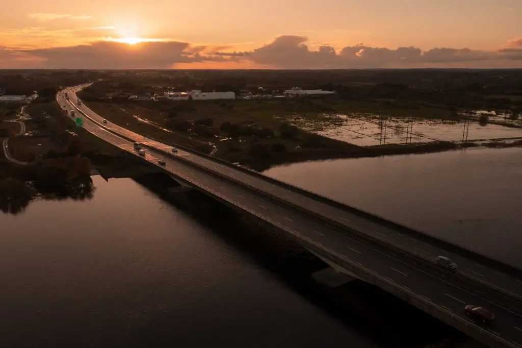
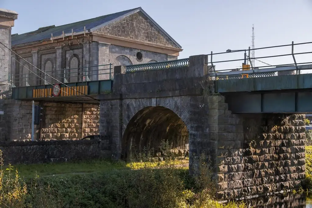
The single most significant element of this undertaking was the design and construction of a new road bridge across the Shannon, the first such bridge to be built in Athlone in almost 150 years.The bridge, which was officially opened in 1991, by the then Taoiseach, Charles Haughey, was designed by Ove Arup & Partners. At the opening the Taoiseach named the bridge “Shannon Way,” but over twenty years later, in 2015, it was agreed to rename it Cumann na mBan Bridge in recognition of the part played by women in the fight for Irish freedom.
The bridge, is a twin deck structure of concrete-box girder design. It is founded on two piers in the river and two abutments on land. For the technically minded it was constructed “by the cast in-situ segmental balanced cantilever method of construction.” At the time of completion in 1991 the Athlone Relief Road bridge and the Liffey Valley bridge were the largest span bridges in the Republic of Ireland.
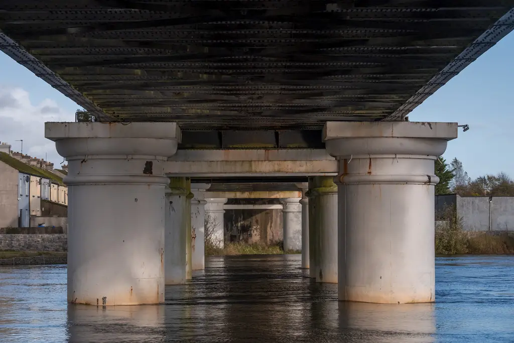
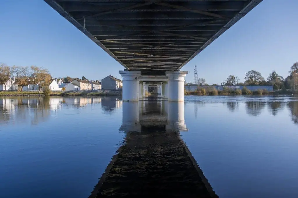
When the Midland Great Western Railway Company was planning its route from Dublin to Galway one of the great obstacles facing them was that of crossing the Shannon at Athlone. By 1849 the engineer, G.W. Hemans, had designed the bridge, the contractor for the project was William Dargan and the ironwork was on order from the U.K. firm of Fox, Henderson & Co. who were also employed to build the pavilion for the Great Exhibition in London at that time. It has been recorded that T.P. O’Connor M.P. (1848 - 1929) Athlone born journalist, author and politician once said that of all the prospects he had seen in Europe, the sight dearest to him was the graceful railway bridge over the Shannon at Athlone. It is a bridge that is still very dear to the people of Athlone today.
This iconic bridge is over 540 feet in length and originally had a central, swivel opening-span to accommodate yachts and other craft with high super-structures wishing to navigate the waterway. This became a fixed-span in 1972. The bridge, is supported on twelve 10-foot diameter cast-iron columns. It is a gem of Victorian railway architecture with its two graceful bow-spring spans. The two rusticated supporting piers at either end add to the impact of the bridge itself. This bridge was first opened to commercial railway traffic on August 1, 1851, with the opening of the extension of the Midland Great Western Railway line from Athlone to Galway. The bridge contract was completed within eighteen months. It was originally planned to sink the columns by a vacuum method but because of the amount of rock in the river bed, they had to resort to the more conventional method of using compressed air to sink the piers – it was the first time that technique was used in this country.
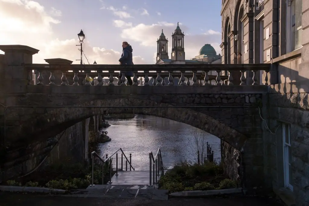
The town bridge has served us well for almost 180 years, it replaced the Elizabethan bridge of 1566. The bridge was part of the package of the Shannon Navigation Works of the 1840s which made the river fully navigable through Athlone. Other features of these works were the building of quay walls, the lock-gates and the weir-wall. The town bridge is a very solid and imposing structure constructed of limestone ashlar with ashlar detailing. The engineer for the project was Thomas Rhodes and the contractor responsible for its construction was John McMahon, who tendered to build the bridge for £23,000. The contract for the building of the bridge and the approach roads was signed in 1841. The bridge was completed and first opened to the public on November 9, 1844. Thomas Rhodes was high in his praise for the work of McMahon, he said that the bridge had been built in a most substantial manner, both as regards the workmanship and the materials used, which were of the best description.
Originally, the western arch had a swivel opening to facilitate navigation. By 1959 it was necessary to replace it. Costs were obtained and a new swivel span would have cost £43,000 whereas a fixed span cost £16,000. The controversy over swivel versus fixed span was the catalyst for the formation of the Inland Waterways Association of Ireland.
In June 1959 a temporary Bailey Bridge was put in place to enable the new fixed-span to be constructed beneath it. For about three and a half years only single-line traffic was able to use the Bailey Bridge. The new fixed span was opened in April 1963. The bridge is sometimes referred to as Custume Bridge, though there is no record of this name ever having been adopted. This confusion probably arose because it leads into Custume Place. Sgt Custume is commemorated in the naming of the army barracks.
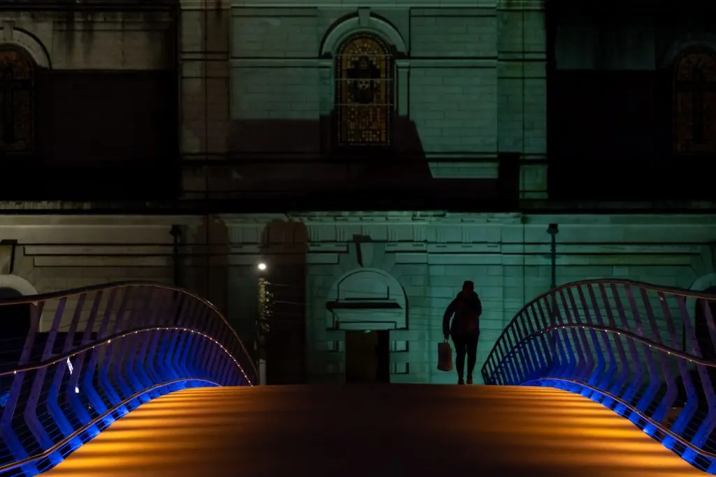
There had been talk for many years of providing a bridge across the Shannon solely for the use of pedestrians and cyclists. Several sites were suggested, both north and south of the town bridge. Eventually, in August 2023, the new bridge was officially opened marking a very significant milestone in the planned 300km Greenway from Dublin to Galway. The opening of this bridge marked the competition of the 108km stretch of Greenway linking the university towns of Maynooth and Athlone. In time this will become part of the “EuroVelo 2” cycle route which will pass through Ireland, the U.K., the Netherlands, Germany, Poland, Belarus and Russia. The bridge was commissioned by Westmeath County Council and work on this elegant structure commenced in August 2021. It was designed by architect Sean Harrington in conjunction with Roughan & O’Donovan, consulting engineers.
Part of the design of this project was to relocate the bronze bust of John Count McCormack by the Cork sculptor, Seamus Murphy. The bust was first unveiled in 1970 and subsequently relocated in 1984 in time for the centenary of the tenor’s birth.It now happily looks across the Greenway Bridge to the Radisson Hotel which is built on the site of Athlone Woollen Mills where John McCormack’s father was employed. This bridge with its sleek and modern design has been warmly welcomed by the people of Athlone.
The two-span, steel girder bridge is supported on a central reinforced concrete pier, with end supports on either riverbank. The structural steel was fabricated in Spain in thirteen parts and transported by road and sea to Dublin Port before being brought to Athlone. The central pier and an inlaid polished and engraved bronze band, serve to emphasise the importance of the meeting point of the ancient east-west highway and the north-south ‘highway’ provided by the lordly Shannon. It marks a new symbolic centre of Ireland.
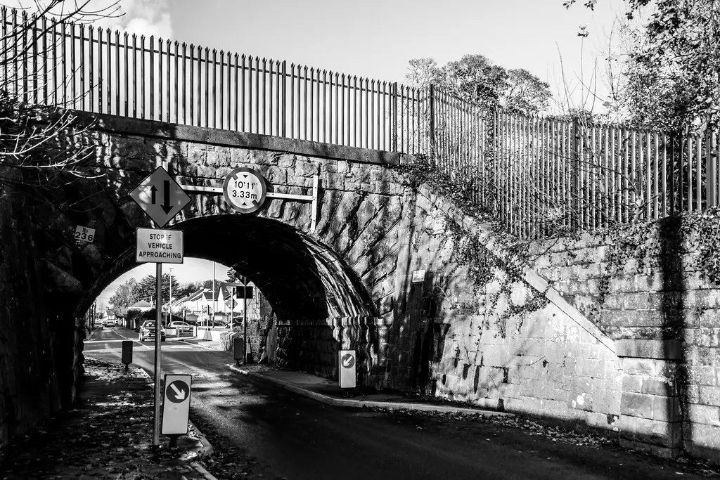
The original Garrycastle Bridge was a narrow, slightly humped structure which crossed above the Athlone to Mullingar railway line. However, with the huge increase in traffic servicing Athlone Institute of Technology (as it was then), Cornamaddy N.S., Solas (Athlone Training Centre), Ericsson, the E.S.B. and the industrial estate at Bliary this bridge had become a bottle-neck which severely impeded traffic flow on this important regional road (R916). The bridge itself was, for many years, considered hazardous to pedestrians, cyclists and motorists.
Following almost ten years of debate, Westmeath County Council announced in 2013 that the National Roads Authority had given the go ahead for the realignment of Garrycastle Bridge at an estimated cost of €6.1 million. The project consisted of the provision of 670 metres of single carriageway regional road, a single span bridge over the old Athlone to Mullingar railway line, the provision of two new roundabouts and 230 metres of reinforced concrete retaining walls, with associated permanent safety barriers and pedestrian guardrails. The scheme also included cycling and walking facilities to encourage more sustainable and healthy forms of transport.
The contract for the work was awarded to Jons Civil Engineering Ltd., a major civil engineering firm which was behind the construction of the Joe Dolan Bridge in Mullingar, described as the longest bridge in Ireland. The work commenced in April 2013 and when the new Garrycastle Bridge was officially opened in May 2014, it completed the final phase of the upgrading of the R916 road. This bridge has proved itself to be an important link in the transport infrastructure of Athlone. It has truly transformed the area, by improving access to Athlone and helping to alleviate traffic congestion. The original Garrycastle Bridge which was completed c1850 as part of the Midland Great Western Railway line has been left in situ.
When Athlone Canal was cut in 1757 it had only one bridge, leading from Connaught Street to the Batteries, as that was then the main road to the West of Ireland. Today there are three road bridges and a pedestrian bridge on the canal, while yet another bridge carries the railway line across both it and Magazine Road. The well-known bridge across the canal was never officially named but rather it got its name by default, it is the bridge which links the Clonown Road with Deerpark Road and it is known affectionately, if not officially, as Mick McQuaid’s Bridge. The campaign for a bridge to be built across the canal, near Heaton’s Mill, for the convenience of the residents in Parnell Square bringing turf home from the bog, and for the convenience of those coming into town from Clonown and Duogue, was fought through the “Letters to the Editor” column of the Westmeath Independent. A caller to the newspaper office was advised to write a letter to the paper but he wasn’t “the writing type.” Eventually, one of the journalists penned a letter for him, and when trying to think of a suitable pen-name, looked down at his desk and spotted a tin of Mick McQuaid tobacco. The rest, as they say, is history.
The original bridge was completed in 1943 and several ideas for a name for it were put forward but no decision was ever reached. Then through local usage it became known as Mick McQuaid’s Bridge by default. This bridge, while welcomed by many locals, was rightly criticised because it impeded boats from south of Athlone, coming any further than the bridge. In 2022 a new bridge, part of the Athlone Flood Alleviation Scheme, was completed. Unfortunately, the high parapet now blocks the view of the canal as it flows to join the Shannon south of the town.
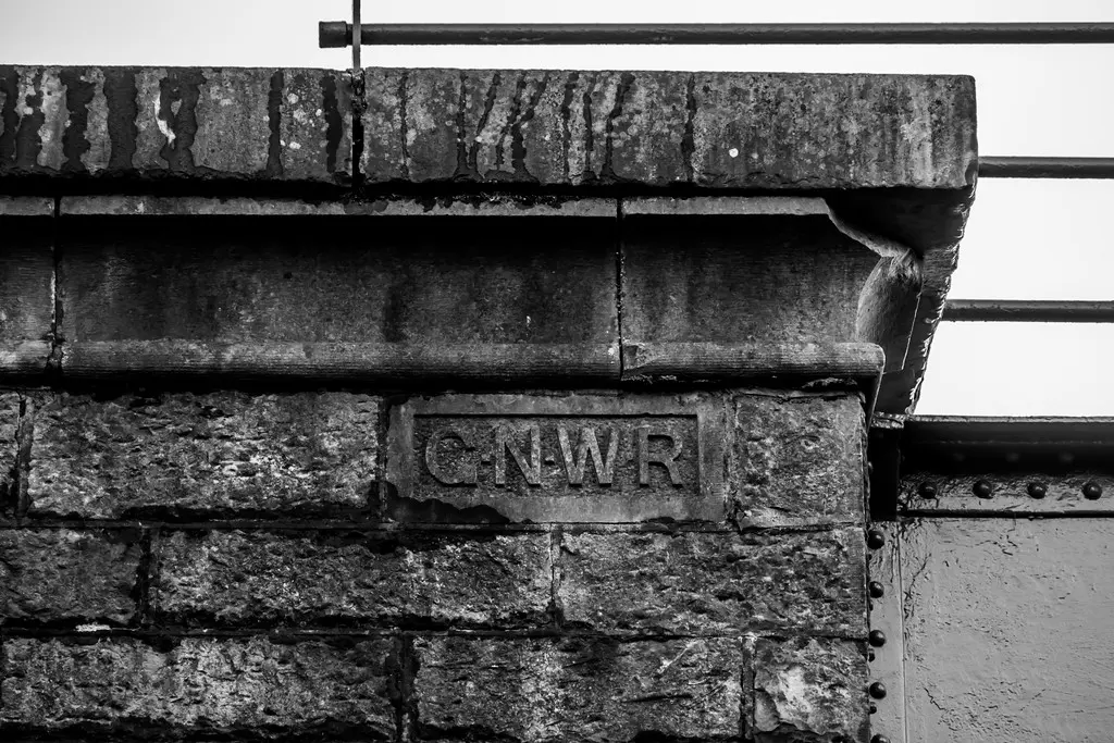
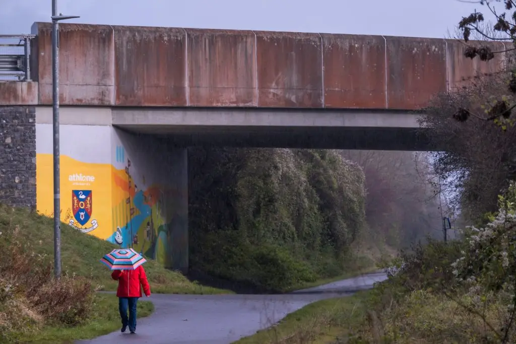
The coming of the railway to Athlone in the 1850s resulted in the building of a many bridges. The one which comes most readily to mind for most people is, of course, the White Bridge, which spans the Shannon but equally important were the many bridges which brought the railway above the roads leading in and out of town. There are two railway bridges which cross above the Coosan Road, these were built by rival railway companies the Midland Great Western Railway and the Great Southern & Western Railway. The competition between these rival companies was so fierce that it resulted in the building of two railway stations in Athlone, one on either side of the town. However, by 1860 agreement was reached between the two companies to end the strife. The Galway Road Railway Bridge, was not built by either company, it was built for Lord Lucan’s Great Northern and Western Railway which opened a line from Athlone to Roscommon in February 1860 running three trains daily in each direction and one on a Sunday. In November 1860 they extended the service from Athlone to Castlerea, reducing the service to two daily trains each way with one on a Sunday.
The intermediary stops between Athlone and Castlerea were: Knockcroghery, Ballymurray, Roscommon and Dunamon. In 1857 the Midland Great Western Railway had contracted to work the new Great Northern & Western Railway extension from Athlone to Castlerea on terms to be settled, they also agreed to put up a third of the capital needed to build the line. When it came to extending the line to Ballina, they revised the terms. By November 1889 the Midland Great Western Railway had bought out the Great Northern & Western Railway. With the letters G.N.W.R. in relief on one of the piers, this bridge is a unique local survivor of that short-lived company.
Situated towards the northern end of Athlone Canal, a canal which was cut in 1757 by Thomas Omer, this bridge has a dual purpose as it spans both the canal and the Magazine Road which runs parallel with it. Magazine Road, which dates from c1800, takes its name from its proximity to the powder magazine in the nearby military barracks. This bridge is an important component of one of the great mid-nineteenth century developments in Athlone, the coming of the railway to the town, but it also reminds us of the importance the canal had for navigational purposes prior to the Shannon Navigation Works of the 1840s.
Several railway companies competed for the rail traffic to the west of Ireland but the first to reach Athlone was the Midland Great Western Railway Company, with their extension of the line from Dublin’s Broadstone Station to Galway. The first train to travel from Athlone to Galway was in August 1851. This substantial three-span bridge, completed in 1850, is located very close to the old Midland Great Western Railway Station which was designed by J.S. Mulvany. It is the first bridge encountered west of the Shannon in Athlone. The walls and piers are of rock faced limestone ashlar and are typical of nineteenth century railway architecture. They are similar to the piers of ‘The White Bridge.’ The bridge has two squared spans with cast-iron railing-topped limestone ashlar parapets, one above Magazine Road and the other above the canal. The rounded central arch is the most decorative feature of the bridge itself and this was to accommodate the canal tow-path. The Shannon Navigation Works once completed rendered the canal redundant for navigation purposes. Had the bridge been built ten years later it is most unlikely that the tow-path would have been retained – today it allows for a pleasant canal-side walk.
The Shannon was not fully navigable through Athlone until the completion of the Shannon Navigation Works of the 1840s. One of the earliest efforts to improve the navigation locally was the cutting of Athlone Canal in 1757. Its purpose was to by-pass the shallow fording point in the town and it proved to be quite effective in this regard. Originally there was only one bridge across the canal, the Battery Bridge, but c1804 the army commandeered that bridge, as part of their preparations for a feared Napoleonic invasion. The bridge gave the military easy access to the series of Batteries being developed to defend the western approaches to the town. At this time a second bridge was built on the canal at Magazine Road to take traffic to the west, this bridge was a wooden bridge until the late 1930s at least. In 1850, with the coming of the railways, a new road was being developed to “accommodate passengers” arriving at the Midland Great Western Railway station to get into town. This offered the opportunity to improve the approach to Athlone from the west by constructing a road from the village of Baylough to join the new “Accommodation Road” (now called Elliott Road) at Ranelagh.
This new road necessitated the building of a third bridge across the canal, originally when it was built it had a swivel span to allow for navigation and was considerably narrower than the present bridge. By the mid-1930s there was much debate about the condition of this corner and the narrowness of the bridge itself. It was agreed to replace the original bridge with a wider bridge but, sadly, without a swivel span. This decision was probably based on costs together with the fact that the canal was no longer deemed necessary for navigation. Once the fixed-span bridge was in place it effectively created a ‘cul-de-sac’ of that portion of canal north of the bridge.
Supported by Creative Ireland